
Date:Aug 8, 1979
Time:7:30 am
Alt.:?? ft.
Temp.:72°
Barom.:steady,
Place:Whisky Camp
Diamond Crossing was filled and No Vacancy signs were out. Well, maybe not, but there sure were a lot of people and animals there. A professional guide service had brought in a least a dozen fisherman to hunt the rainbow trout. I think they had cleaned out the entire creek. One of the trailhands had mentioned that Rob had been through the area two days before. Good for him. I checked the map and decided to head to Whiskey Camp to spend the night. I got in about 6:00 pm, and didn’t take long to meet Jerry and he invited me to share his camp. Jerry is a photography major at Sacramento State and builds wonderfully simple 4×5 bellows cameras, I really would like him to build one for me, pretty neat cameras. Two or three other parties have also made camp.. This appears to be a major crossroads of several trails. Unfortunately no one had been on the trail that I planned to take this morning.
Date:Aug 8, 1979
Time:11:30 am
Alt.:?? ft.
Temp.:85°
Barom.:steady,
Place:Below Tinker Knob
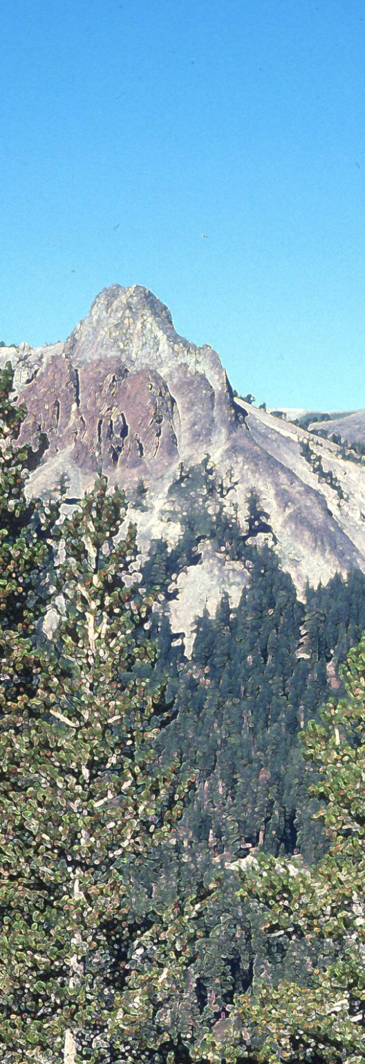
What a morning! Trail rumor had it that a new section of the crest trail trail had been completed that would take me directly to Donner Pass and bypass the Old Soda Springs route. Great, I’m ready for it. The new section was supposedly at Tinker Knob and I had to climb Granite Chief to get to Tinker Knob. The sun was really pounding the trail, and it seemed like I was climbing from one spot of shade to another. As I crested the saddle, the view on the other side was spectacular. Lake Tahoe stretched out, ringed by mountains. Below my position, about a quarter of a mile down was the High Camp ski lift of Squaw Valley. I could see maintenance men crawling on the structure. I’m sure they didn’t expect someone was even higher up the mountain than they were.
On to Tinker Knob.
Date:Aug 8, 1979
Time:1:30 pm
Alt.:?? ft.
Temp.:72°
Barom.:steady,
Place:Tinker Knob
Met two older women on the way here. I mean pushing seventy with full packs. I asked if they had seen the new trail and they replied that they had seen the sign. I tried to warn them about the Granite Chief trail. They chuckled and said that they knew about it, they had built it, and oh by the way, they had already climbed Tinker Knob this morning. Okay!
If Granite Chief was bad, then the trail up Tinker Knob was off the scale. Each step was climbing a foot in elevation. It was worse than stairs. At the top, sure enough, there was the sign and a well worn trail to Cold Springs. It didn’t look that new but I headed down the face of Tinker Knob as the trail swung towards the east. The East! I wanted to go north and now I was two miles down the mountain, heading east. I looked at the ridge to the north of me and determined that that is where I should be. I could even see a bit of the trail through the trees. Nothing to do but backtrack and climb Tinker Knob once again.
An hour later and I was trying to find the new trail. Following the natural lay of the land I spotted what appeared to be a trail curving around the slopes of Mt. Anderson, about a mile away. A half an hour later I was on the new trail, heading towards Donner Pass.
Date:Aug 8, 1979
Time:5:30 pm
Alt.:?? ft.
Temp.:72°
Barom.:steady,
Place:On the Ridge
This is great, the trail is about three feet wide and it runs exactly on the ridge. On my left is the Pacific Slope and on my right is the eastern slope leading to the Nevada Basin. Verdant green on my left, dry brown desert on my right. The trail even had a curb made of small rocks. Best trail building I had seen and perfectly flat, placed on the most dramatic ridge of the Pacific Crest. If this goes all the way to Donner Pass then I will be one happy camper.
Unfortunately it doesn’t. I mean when it stopped, it just plain stopped. It didn’t gradually fade away, it terminated. Back to ribbons in the trees, at least until Donner Peak. It’s getting late and I’m still on this ridge, no water, not a place I want to spend the night.
Date:Aug 8, 1979
Time:9:30 pm
Alt.:?? ft.
Temp.:66°
Barom.:steady,
Place:Soda Springs
End of the trail. In the morning I plan to call Sherry and have her rescue me. I’m tired and I want to go home.
I found a road that appeared on the ridge and followed it to the Cold Stream pass. This was the pass that the emigrants actually used when coming up from Donner Lake. In the fading afternoon light it was a bleak place and I didn’t feel much like lingering. I wondered how it was that I came here, stumbled upon this. I turned back and hiked back up to the ridge, looking for a trail leading to Norden. I found a road that seemed to wind it’s way down the mountain, but if I followed it, it would be dark long before I got to the bottom. After pondering the choices, I simply went over the edge. I mean directly over the edge and down the mountain.
It was so steep that I could grab the tops of small trees and swing down the face where I would let go and grab another, swinging left and then right. When the trees thinned out I stopped to check my progress. It was unorthodox, it didn’t appear to harm anything, and I was making remarkable time. So I continued, hopping down the face, doing a version of downhill skiing turns, and then back to the tree tops when available. When the timing was just right I could grab the next tree before letting go of the last, and the result was that I could travel downhill twenty or thirty feet without touching the ground. It really was the most remarkable feeling. Near the end I could see a row of cabins next to the mountain and if I veered to the right I could almost land in their backyard. Two or three minutes later, I fell into this woman’s backyard. She was outside raking or gardening or something, it must have seemed to her that I fell from the sky, because plop, there I was, no advance warning and no trace of where I came from. She didn’t yell or scream, but she didn’t answer my questions of how far away was Norden, so I tipped my hat and went through her gate to the road.
Norden was basically a collection of cabins and highway maintenance sheds. Sand for frozen highways, stored in steep roofed green buildings. I walked the last few miles to Soda Springs, where I might get something hot to eat.
Just outside of town there was a vacant lot that I made home until the morning.
